
Top 10 Best Walks in the UK
5 April 2023
With more and more people planning to holiday in the UK, there’s never been a better time to explore the most beautiful parts of our little island. With stunning landscapes to enjoy from mountains to wild moorlands, sweeping beaches and rolling countryside, the nation’s favourite way to experience the best the UK has to offer has to be on a nice long walk.
To help you decide where to plan your staycation, we have conducted a survey and polled the Great British public to find out the top 10 best walks in the UK. From one end of the country to the other from the mountains to the sea, our respondents have helped us to compile a range of walks for budding hikers and amblers to explore.
Our Top Walks

- The Thames path, including the London Wetland Centre, London
- Porthleven to Lizard Point, Cornwall Coast
- Loughrigg Fell, Lake District
- Gordale Scar and Malham Cove, North Yorkshire
- Padley Gorge, Peak District
- Stac Pollaidh, Scottish Highlands
- Winchcombe to Cleeve Hill, Cotswolds
- Bickerton Hills and Sandstone, Cheshire
- Sycamore Gap, Northumberland
- Llyn Dinas, North Wales
Whether you’re after a short stroll taking in views with your family or looking for a more challenging walk with scrambles included, these top 10 walks cater for a variety of different abilities.
From the wily heather cladded Yorkshire moors to a hidden corner of Utopia in the capital, mythical stories buried in the hills of Wales and the curious tales of Cornish coves, with the weather warming up, there’s no better time to dig out your trusty walking shoes, get outdoors and explore the best walking trails in the UK and the stories behind them.
Find out a little more below about each walk in the top 10:

1. Thames Path and London Wetland Centre
Start: Thames Path
Finish: London Wetland Centre
Distance: 8 miles
Duration: 2 hours 40 minutes
Difficulty: Moderate
The Thames Path is a National Trail and stretches from the Cotswolds to London for a total of 184 miles, this section is a manageable walk of approximately 8 miles and covers a stretch that you would never guess is located in a capital city.
If you’re looking for peace and quiet, a sense of what this part of England was like in years gone by and some great opportunities to spot wildlife, this is the walk for you.
Start at Richmond Railway Station and turn left out of the station and follow the high street until you reach the riverfront. Turn right and set out on the Thames Path. On this stretch you can take in the scenes of the ancient oaks of the Old Deer Park, Isleworth Eyot and Syon House across the river.
As you round the bend and approach Kew Bridge you might like to stop for refreshment in one of the long-standing local pubs on this side or cross the bridge to the village-like Strand-on-the-Green on the other.
Continue on the south-side path and enjoy wildlife spotting at the ‘Leg O Mutton’ nature reserve before admiring the Georgian architecture of Chiswick on the opposite bank. Pass under Hammersmith bridge and complete the last stretch of tow path approaching the London Wetland Centre.
The London Wetland Centre covers 100 acres and was originally four Victorian reservoirs which were shaped into a wide range of wetland habitats and features before opening to the public in 2000. It’s home to a wide range of migratory wader birds, ducks and geese, native British birds, insects, reptiles, water voles and otters all living in this beautiful landscape.
When you’ve completed your visit, it’s a 15-minute walk back to Barnes station, or a short bus ride to Hammersmith rail and underground station.
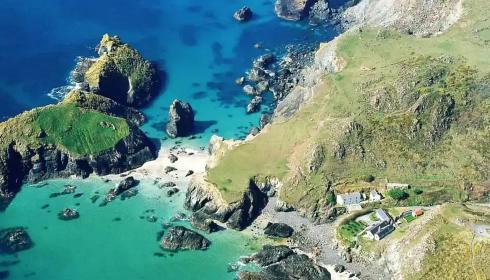
2. Porthleven to Lizard Point, Cornwall
Start: Porthleven Harbour
Finish: Lizard Point / Lizard village (with buses back to Helston)
Distance: 13.4 miles
Duration: 6 hours 15 minutes
Difficulty: Moderate
It’s not hard to see why this walk which takes in the beautiful coves and cliff tops of the Western side of the Lizard peninsula is the nation’s second favourite. Walking the Southwest Coast Path you can fill your imagination with scenes of smuggling and sunken pirate galleons whilst marvelling at the stunning beauty of the wild cliffs and coastline.
This is a moderately challenging walk as you descend and ascend the cliff path and the various coves along the way. Some parts are also more challenging where the path is steeper and narrow, but it is suitable for anyone with a good level of experience.
On leaving Porthleven you come to the sands of Loe Bar which is a two-mile stretch of sand to Gunwalloe Cove and according to legend was where King Arthur’s sword Excalibur was thrown on his death. After exploring Gunwalloe, climb to the cliff tops and follow the path to Church Cove, which has had its share of shipwrecks - so look out for gold coins as you cross the sand!
The next cove to discover is Poldhu. The headland here is the site of the Marconi monument, marking the location of the first transatlantic radio message transmission. Next is sandy Polurrian Cove, and then half a mile further on is Mullion Cove, a small traditional Cornish fishing harbour, with an off-shore island.
Leaving the cove, follow the cliff-top path to Predannack Head – a wild and isolated headland where rare heathers and wildflowers abound. Following the path, you reach the picturesque Kynance Cove, with its unusual rock formations and pockets of sandy beach only accessible at low tide, so don’t get caught out!
Ascending the cliff to the coast path, you’ll start on the last mile to Lizard Point – the most Southerly point in the UK and home to nesting pairs of Choughs, a working lighthouse and a small village to explore.
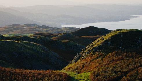
3. Loughrigg Fell, Lake District
Start and Finish: Ambleside main car park
Distance: 6.2 miles
Duration: 2.5 hours
Difficulty: Easy – Moderate
Loughrigg Fell offers an easily accessible walk that will bring you at one with nature. This Lake District walk explores a variety of beautiful landscapes, and for relatively moderate effort, will reward you with a number of breath-taking views of dramatic terrains formed around the large lakes and ever-changing sky lines.
Exploring the 335m summit of Loughrigg Fell - the naturally flat Loughrigg Terrace overlooking Lake Grasmere and the man-made Rydal Cave - is a perfect half-day walk from Ambleside that’s suitable for all the family.
Starting at the main car park in Ambleside, follow the footpath to Miller Bridge and head up the bridleway, the initial climb is steep, but eventually gives way to a rough track. After crossing the stream, head left, and you should approach the summit.
On the descent you can enjoy views of Loughrigg Tarn and Rydal Cave which can be found on the northside above Rydal Water. This is a man-made cave from the result of quarrying for slate. The cave can be entered by the public and has stepping stones to cross.
The return to Ambleside is along the quiet Under Loughrigg road. A popular walk, there are a few steep sections but the views at the top are definitely worth the climb.
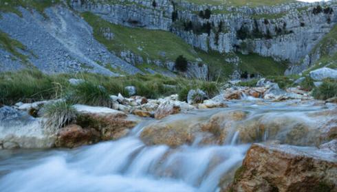
4. Malham Cove and Gordale Scar, North Yorkshire
Start and Finish: Malham Village
Distance: 7.6 miles
Duration: 3 hours
Difficulty: Difficult
One of the most iconic landscapes in the Yorkshire Dales, exploring Malham Cove is a must for walkers and climbers alike - so it’s no surprise it features in our top 10. This is a beautiful and action-packed walk taking in three natural beauty spots with some rugged terrain, and stunning views over the Yorkshire Dales.
The cove is formed from limestone scar, a deeply eroded limestone pavement, approximately 260 feet in height. The gaps in the limestone, also known as grykes, create a unique habitat for local wildlife, flora and fauna. This popular circular walk takes in Janet’s Foss and Gordale Scar, beginning with a low-level walk, followed by a scramble and an eventual descent into Malham Cove.
Setting off from the village car park, turn right over the footbridge and follow the signs for Janet’s Foss, foss being an old Scandinavian word for waterfall. Local legend has it that Janet was a fairy that lived behind the waterfall. Follow the path up to the left of the waterfall and follow signs for Gordale scar, a spectacular waterfall cut into the limestone rock.
The walk then heads up the ravine, although there is an alternative route to this if weather does not permit. The walk will then take you past the stunning Malham Tarn, ending up at the top of Malham Cove. Take care over the limestone pavement and descend back into Malham with a beautiful panorama of the countryside in front of you.
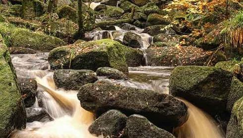
5. Padley Gorge, Peak District
Start and Finish: Woodcroft car park on the Longshaw Estate
Distance: 3.7 miles
Duration: 2 hours
Difficulty: Easy - Moderate
Padley Gorge is a beautiful ancient, mixed woodland, home to a wide range of flora and fauna. It’s the best place in the UK to see Pied Flycatchers, and the Yarncliffe wood is covered by a beautiful blanket of bluebells each May. This walk also takes in the Totley Tunnel, which at 5.6km in length is one of the longest tunnels in the country.
From the Woodcroft car park, follow the signs to the estate’s National Trust tearoom (perfect for stopping for coffee and cake), and then pass the pond before heading downhill into Granby Woods.
After you emerge at Granby Barn, head over the Burbage Brook bridge, before following the path to Padley Gorge. Follow the path to the bottom of the Gorge and cross another picturesque wooden bridge, then continue along to the Totley Tunnel and Grindleford Station.
At this point either cross over the railway bridge or take a well-deserved break at the Old Grindleford Station Café, which is legendary for its huge portions of honest food and pints of tea.
Next follow the trail along the brook until the path heads uphill and continue along the track through Yarncliffe Wood until it re-emerges near an interesting disused quarry. Then take the nearby footpath and you’ll return back to the Longshaw estate.
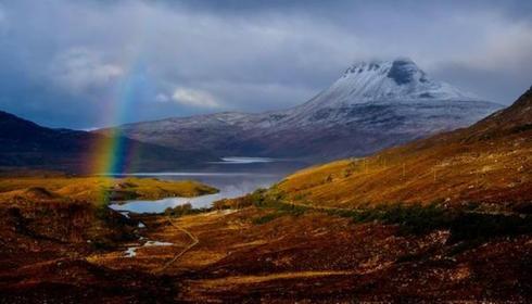
6. Stac Pollaidh, Scottish Highlands
Start and Finish: Stac Pollaidh Car Park, Ullapool
Duration: 2.8 miles
Time: 3 - 4 hours
Difficulty: Moderate-difficult
Stac Pollaidh means ‘steep rock by the pool’ – which is exactly what you get on this famous walk which pays big rewards with its beautiful views of the natural Scottish landscape.
Leaving the car park, you ascend a steep footpath route where you will shortly be greeted by stunning views of other summits and landscapes including Loch Lurgainn. After having a photo or two, follow the trail around the mountain base where Cul Mòr and Suilven become the prominent scenes on offer.
The trail will eventually lead you to a junction, where you can either stay along the bottom of the mountain for an easier walk, or pursue the Eastern summit. If you really want a challenge, then the Western summit is the one for you, reaching an elevation of 612m with no designated path, so scrambling skills are required! Don’t worry if getting to the top isn’t for you, Stac Pollaidh is renowned for its quirky features, with years of erosion leaving the sandstone in some stunning formations which can be seen from wherever you are.
When you’ve finished admiring the beautiful scenery, simply follow the trail down back towards the junction, turn left and through a gate where you will follow the path back to the car park. With the choices of summits and beautiful views, this trail is one for all!
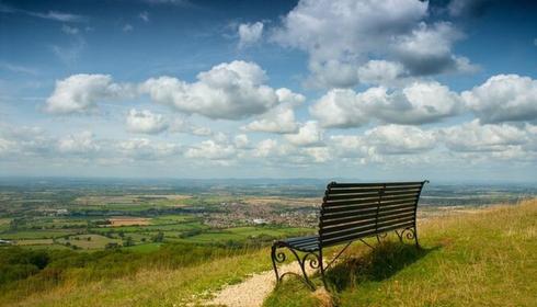
7. Winchcombe to Cleeve Hill, Cotswolds
Start and Finish: Winchcombe near the tourist information centre and Almsbury Farm
Duration: 10 miles
Duration: 4.5 hours
Difficulty: Moderate
This is a circular walk from Winchcombe to Cleeve Hill which uses part of the Cotswold Way National Trail and offers incredible views of the changing Gloucestershire landscapes.
Start the walk in Winchcombe near the tourist information centre and Almsbury Farm. Pick up the Cotswold Way and head south to Wadfield Farm. You will arrive at Belas Knap, a Neolithic burial site dating from around 3000 BC, you can explore the site including a false entrance and a variety of side chambers, which you can access separately.
Following on from Belas Knap, head west to Wotfield Farm before coming to Cleeve Hill, the highest point in the Cotswolds Hills. From a height of 1,083 feet (330m) Cleeve Hill is the perfect place to admire the surrounding rolling hills, the River Severn and Cheltenham racecourse.
Once you’ve taken in the glorious views, continue northwest, walking along the edge of Nutterswood and Thrift Wood before coming to Woodmancote. Head east past the golf course towards old Postlip Hall and pick up the Isbourne Way. You will enjoy a walk along the River Isbourne, which will take you back to Winchcombe and your starting point, where the circular trail ends.
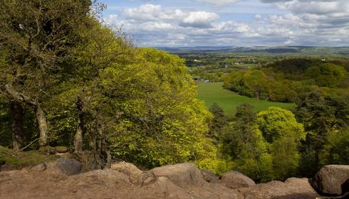
8. Bickerton Hills and Sandstone, Cheshire
Start and Finish: Poacher Pub, Bickerton, SY14 8BE
Distance: 3 miles
Duration: 2 – 2.5 hours
Difficulty: Moderate
Characterised by its sandstone landscapes, on this walk you’ll ascend through the heather-clad countryside and explore the finest section of the Cheshire Sandstone Ridge. You’ll also get the chance to take in the panoramic views across to the Clwydian Hills of the Dee Valley and look out for Bertie and Bella, the Liver Birds soaring above Liverpool’s skyline.
From the car park, start out on Coppermine Lane and take the steps up to the kissing gate and follow the left path to reach the top of the hill, continue along the path following the signs for Coppermine Lane. Turning left, follow the lane downhill and take the path that passes the sandstone cave. On this trail you will spot a tall chimney on the brow of the hill, a remnant of Cheshire’s copper mining industry. Cross the brook and follow the path until you reach the Sandstone Trail.
Join the sandy trail heading uphill to Rawhead continuing over the kissing gate. Although this is a relatively short section of the 34-mile Sandstone Trail the views at this point are particularly stunning. Following the trail for the Mid-Cheshire Ridge, you’ll pass red-sandstone ridges and Bronze Age settlements, make sure you keep to the path guided by the signposts to Bulkeley Hill.
Pass through the gate and take the path that leaves the Sandstone Trail and follow the signs for Stonehouse Lane and the Bickerton Poacher, just in time for some well-earned refreshments.
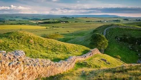
9. Sycamore Gap, Northumberland
Start and Finish: Housesteads Visitor Centre
Distance: 5.2 miles
Duration: 3 hours
Difficulty: Moderate
Northumberland was once hailed as the powerhouse of England, a land where saints, kings and Viking raiders carved rich history into the foundations of our country today. This walk provides an opportunity to enjoy the entwining of nature and history as you follow Hadrian’s wall and the Roman Military Way situated in a stunning landscape.
Start from the visitor centre at Housesteads and follow the path to the Roman Fort. The fort was built between 122-132 and you can take a look around the barrack blocks and hospital, as well as the interactive museum, if you wish. When you are ready, leave the fort and turn left to follow the World Heritage Roman wall footpath enjoying magnificent views of the wall undulating in the distance over Cuddy’s and Hotbank Crags.
After a further mile you will reach the top of Hotbank Crags. Continue downhill from here passing Hotbank Farm on the right until you reach Crag Lough. Climb up from here through the woods for magnificent views of the Lough and surrounding countryside. At the end of the Crag you cross over a stile and drop down steeply to reach the iconic 'Sycamore Gap' – also known as the ‘Robin Hood Tree’ – which is a sycamore tree standing strong next to Hadrian’s Wall.
Then follow a path which runs parallel to the Wall and follows the route of the Roman Military Way. Enjoy the dramatic blending of civilisation and nature’s course on your way back past Hotbank Farm and wind your way back to Housesteads Fort for a return to the visitor centre.
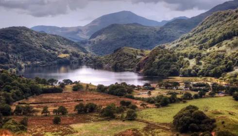
10. Llyn Dinas, Wales
Start and Finish: Llyn Dinas car park
Distance: 1.75 miles
Duration: 1.5 hours
Difficulty: Easy
Llyn Dinas is a picturesque lake situated within Snowdonia National Park in North Wales. This walk takes you around the circumference of the lake, predominantly the riverbanks and so is relatively flat. It offers a mix of both stunning mountain and lakeside scenery you will not soon forget.
The walk begins at the lake’s car park on the left as you leave Beddgelert. Follow the path until you reach a small footbridge, cross this and continue on the marked trail. A couple of stiles will then bring you to Llyndy Isaf’s farmhouse.
Continue on from here to the main road past the farm until you see a small road on the left, take this road until you eventually meet a bridge. You can now follow the main road back to where you began.
If you want more of a hiking challenge, you can add the ascent to the peak Dinas Emerys to this walk. This summit has a mythical past and was the site of a castle that refused to be built due to two dragons being trapped inside. King Vortigern’s men dug the two dragons out and they fought. The white dragon fled and the red dragon returned to his lair and became the national symbol of Wales. The summit is situated WSW of the lake and the hike up to the top also takes in the scenic waterfall Merlin’s Pool.
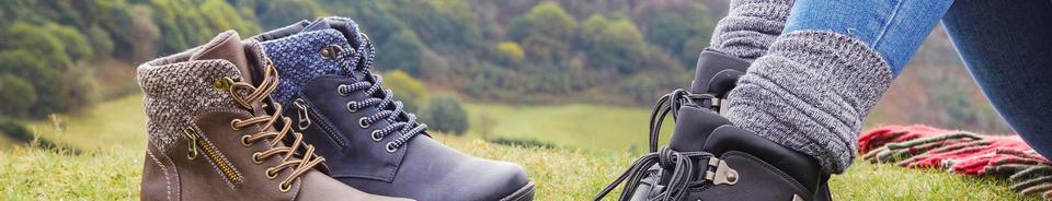
Choosing the Right Shoes for Walking
Whether you’re a well-seasoned walker or not, you’ll probably appreciate just how important a good pair of walking shoes can be; they can mean all the difference when feeling comfortable and supported is concerned. So before heading out onto your chosen walk(s) from our top 10, you’ll need to pick the best shoes for the terrain, the weather and of course what fits your feet.
For hot dry days, men’s walking sandals are preferable, offering the refreshing coolness your feet will crave on the trail with cushioned comfort and a flexible, traction outsole which is great for those trekking off the beaten track.
Can Trainers be Used as Walking Shoes?
In a nutshell yes, trainers can go the extra mile (quite literally) where walking is concerned, lightweight, flexible, shock-absorbing, the list of benefits really does go on and on.
Because they’re so comfortable, our collection of trainers will be the shoes you’ll want to wear all day even when you’re not walking. From traditional lace-up trainers with an adjustable fit to slip on trainers, it’s not just about practicality and performance, but comfort is also key.
Before you invest in a new pair our trusty guide to wearing trainers as walking shoes, will help you to pick out the best pair for your walk.
Be Inspired
Check out our latest blogs.